Drought conditions slowly expand
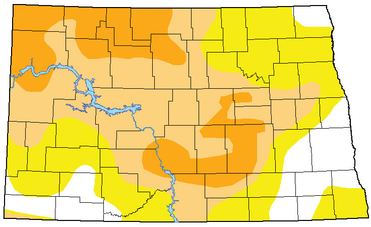
Submitted Photo Drought conditions across North Dakota have continued to expand in range and severity for the past several weeks. Severe drought is indicated by the dark brown areas on this map released by the U.S. Drought Monitor. Light brown is considered to be in moderate drought and yellow “abnormally” dry.
It’s no secret that soil conditions throughout the Minot region and across the state are very dry. Again this week the U.S. Drought Monitor reports an increase in both the percentage of the state affected by dry conditions and the severity of drought conditions.
Fortunately, it is not the spring planting season when soil moisture is needed to help germinate crops and spur growth in pastures. Nevertheless, rising drought conditions heading into a period that historically has experienced very little precipitation is concerning.
“Right now the outlooks are kind of for a dry and warm fall,” said Todd Hamilton, meteorologist, National Weather Service in Bismarck.
Forecasts issued by the Climate Prediction Center conclude North Dakota is favored to receive less than normal precipitation at least through the end of October. “Less than normal” precipitation outlooks for the latter months of the year are not as significant as similar outlooks for spring and summer due to the fact that precipitation is usually very low Oct.-December. That means “less than normal” precipitation for the period is not a major deviation.
Average precipitation for Minot in October is 1.16 inches, November 0.75 inches and December 0.38 inches. To date, much of the state is well below normal rainfall totals, which is reflected in the latest Drought Monitor.
“It has been awfully dry for the last couple of months,” said Allen Schlag, hydrologist, Bismarck NWS. “The Bismarck area is as dry as I’ve seen it in 20 years.”
Schlag noted the continued increase in recent weeks of the areas of the state considered to be in “severe drought,” but cautioned that advancing to “extreme drought,” the next category in the Drought Monitor ratings, is not a given.
“A dry fall is fairly common in North Dakota,” said Schlag. “By and large we are not seeing conditions to suggest extreme drought, not that it can’t happen, but a really dry September, October and November is not that unusual. You’d have to take into consideration a much longer time frame before seeing any further degradation. In winter the most likely scenario is improvement or stagnation.”
While several days of high winds have helped exasperate soil moisture conditions and more windy days are in the immediate forecast, it is not likely to have an impact on soil moisture. The reason why, said Schlag, is that there’s not much moisture remaining in the upper level of the soil.
“Surface soils are already so dry that there’s little soil moisture remaining where the wind can do much to it. Wind will usually do a good job drying out the upper two to three inches of soil but anything below that is usually protected from wind,” explained Schlag.
While drought conditions can remain throughout the winter, any significant changes could come from snowmelt and the region could be setting up for more than usual snowfall this winter. A La Nina that was considered a few months ago to be a long-shot to have much of an impact on the United States this winter has continued to develop. It is now considered an 85 percent certainty.
La Nina is a cooling of ocean temperatures that generally results in a winter that is wetter and colder than usual, particularly across the northern U.S. The snowmelt or spring rains could quickly alleviate dry conditions.
“We don’t need that much moisture,” said Schlag. “Come spring about one and a half inches of moisture to reset our perception of drought. About mid-March if the snow melts and runs off a lot of moisture will go into the soil, replenishing that which our farmers desperately need.”
Local News

Auction raises more than $135,000 for Team Minot
Governor’s Photo Contest invites entries
BISMARCK — The 2026 North Dakota Governor’s Photo Contest for Travel and Tourism is now open, inviting North ...
Police impound auction scheduled for Saturday
The Minot Police Department will host its 2026 impound auction on Saturday, May 9. Seifert Auction Service will ...
Supreme Court denies BEK TV’s petition
Learn about native fish at Confluence