Arctic cold weather sends temperatures plunging across North Dakota
Extreme cold grips region
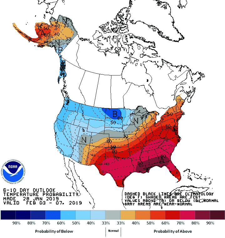
Submitted Photo This weather outlook issued by the Climate Prediction Center singles out North Dakota as the only state to have a very high probability of below normal temperatures though Feb. 7.
The coldest temperatures experienced in several years have descended upon the Minot area and much of the northern United States. Toss in wind chill readings and the numbers becoming numbing.
Langdon, in the northeast section of the state, was listed as having a temperature of minus 31 during the noon hour Tuesday. The wind chill there was minus 58. In comparison, at that same time Minot was warmer at minus 17 with a wind chill in excess of minus 40. The National Weather Service warned Tuesday that even lower readings could be expected Tuesday night and Wednesday morning.
A NWS statement issued Tuesday read, “A prolonged period of life threatening cold through Thursday morning. Wind chills near 60 below zero.”
The Minot region was expected to see temperatures close to minus 30 by this morning, but farther to the east the NWS forecast was even more extreme. Lows in the forecast for this morning ranged from minus 36-41 from just east of Minot to the Red River Valley. International Falls, Minn., accustomed to being the coldest place in the nation, had a forecast for minus 40 degrees this morning with a chance of being even colder Thursday.
Wind chills approaching minus 60 over much of North Dakota added to the cold weather concerns. The NWS warned that exposed skin could suffer frostbite in as few as five minutes. Minot is expected to see “light and variable” winds today. However, combined with a daytime high near 10 below zero even the expected light winds are likely to produce wind chill readings of minus 40 or lower.
As cold as the temperatures are, and have been for the past few days, they have not been record breaking. Minot’s coldest days in January corresponding to Monday through Thursday of this week were minus 40 in 1915, minus 37 in 1916, minus 38 in 1916 and -33 in 1918. Minot’s coldest day on record is minus 47 on Jan. 13, 1916.
Also worth noting is the vast swings in temperature possible for the Minot region. Minot’s record high temperature for January is 61 degrees in 2012. Perhaps even more telling about the area’s weather is a difference of 99 degrees between the Jan. 28 high of 59 and the low for the same date – minus 40.
The NWS says the Minot area should experience temperatures well below zero tonight, perhaps in the minus 15 range, before warming up to as high as 10 above Thursday. By Friday, says the NWS, the Minot area should see temperatures in the upper 20’s on the plus side of zero.
The Climate Prediction Center’s latest long-range outlook gives North Dakota the distinction of having the greatest possibility in the United States of having below normal temperatures through next Thursday. The good news in that outlook is that seasonal average temperatures continue to rise slowly at this time of year, meaning even below normal temperatures in the single digits above zero will seem quite warm in comparison to the current blast of Arctic air.
Safety rules for Wind Chill
Warnings
*If you must go outside, dress in layers of loose-fitting, light weight, warm clothing. Cover the entire body, including hands and face. Be sure to wear a hat. Exposed skin can freeze in a few minutes.
*Do not overexert yourself in the cold, and avoid staying outside for too long. Do not make yourself vulnerable to falls or other accidents.
*Avoid driving into remote areas; stalled motorists could find themselves in extreme danger. If your
vehicle becomes disabled stay inside and wait for help to arrive. You should have blankets and non-perishable foods in your vehicle.
Source: National Weather Service
Local News
Ranch dedicates new treatment center

Minot native receives national recognition for scholarship
Election tone speaks loudly as midterms near
After voters in some states took part in local elections last week, the political world now looks ahead to the 2026 ...

INSPIRITUS awards grants, launches Twice Blessed
Wildlife roaming around Douglas area
Karen LoneFight of White Shield took these photos of wildlife in and around a slough by Douglas. The photos were ...
Reflections: God is enough through 51 years, 51 months
Recently, a mom, apparently overwhelmed by her husband’s job challenges, three young children, and financial ...