Climate predictions show colder, snowier winter for ND
BISMARCK – North Dakota could be in for a colder than normal winter, with potential for more snow, particularly on the back side of winter, according to climate predictions released by the National Weather Service in October. “It is very unlikely that we will have a warm winter, just based on historical data. It could be close to average but the majority of the time it does end up colder than normal, which is what we’re favorable for,” NWS meteorologist Megan Jones, Bismarck, said during an Oct. 16 advisory based on newly released national Climate Prediction Center data. Jones explained a La Nina climate pattern is driving the predictions, but because it is weak, there’s increased chance of other climate factors overriding the pattern and influencing the weather. The El Nino Southern Oscillation (ENSO), which is a large-scale climate pattern based on sea surface temperatures in the equatorial Pacific Ocean, influences the global weather, especially in the winter, Jones said. ENSO has warm (El Nino) and cold (La Nina) phases, as well as a neutral phase. “They are favoring that La Nina condition to continue through meteorological winter before, eventually, we’re going to transition back to the neutral phase of the ENSO circulation,” Jones said. “Typically, when we have a La Nina, we end up with a blocking high pressure in the North Pacific Ocean that leads to a more variable polar jet stream, which makes it a lot easier for that colder arctic air to filter into the northcentral United States. “When we have a weaker event, like we do right now, you are lowering the probability that you see the expected pattern. It doesn’t mean that you won’t get the pattern,” she added. “You are just lowering the probability that you’ll see that pattern because other factors can come into play.” The November outlook shows near normal or above normal temperatures, especially over the first half of the month. However, the precipitation outlook favors above normal precipitation across the state. “It really is hard to talk about average temperatures and average precipitation in the fall, just because things change so quickly,” Jones said. “On October 1 for Bismarck, the average high temperature is 66, and on the last day of November, the average high temperature is only 34, so we are going through a lot of changes in the fall. “It’s also important to note that the average monthly precipitation drops off quite a bit from October, where it’s just under an inch and half, to November, where it’s not even three-quarters of an inch. Those are values specific to Bismarck, but they are pretty applicable across the area,” she said. The winter outlook overall shows a 40-50% chance of below normal temperatures and above normal precipitation, with a somewhat lower chance but still above normal precipitation in the southeast section of the state. “This is certainly something to be paying attention to, where you’ve got all the state favored – at least leaning towards – above normal precipitation,” Jones said. That outlook for cooler than average temperatures remains from January into April. The Climate Prediction Center is less confident about precipitation chances from February-May, with no clear outlook. Although snowfall outlook is difficult to assess, weak La Nina years do support a more active season, Jones said. “There are some signs that during weak La Nina winters, you end up with a more active back half to the season,” she said, suggesting snow in January-March. However, she said models also suggest it may be a more active season for snowfall overall. Jones noted it is rare to have three consecutive seasons with snowfall well below average. Bismarck, which averages 50.5 inches of snow, recorded about half that last winter and just over 60% of normal the previous winter. “Historically, and with the forecast and some of the things we’ve seen in guidance, we are just finally going to get more snow than we have in the past two years,” Jones said. “We also do typically get a December storm when we’re in this pattern. How strong the storm, where it is – that’s still to be determined, for sure, but we do typically see some sort of December storm when we’re in this pattern.” Long-term predictions can be fickle, though, as Jones pointed out. “Even though we are favored for below normal temperatures and above normal precipitation, there is always a probability that is not going to happen. This is kind of the world we live in, especially with climate forecasting, where it can be pretty hard to categorize an entire season,” said Jones, who noted the current outlook is valid for three months. “Again, we’re certainly more strongly favored for near normal to below normal temperatures, but for the Bismarck area, there’s around a 24% chance that we end up with above normal temperatures for that season.”
BISMARCK – North Dakota could be in for a colder than normal winter, with potential for more snow, particularly on the back side of winter, according to climate predictions released by the National Weather Service in October.
“It is very unlikely that we will have a warm winter, just based on historical data. It could be close to average but the majority of the time it does end up colder than normal, which is what we’re favorable for,” NWS meteorologist Megan Jones, Bismarck, said during an Oct. 16 advisory based on newly released national Climate Prediction Center data.
Jones explained a La Nina climate pattern is driving the predictions, but because it is weak, there’s increased chance of other climate factors overriding the pattern and influencing the weather.
The El Nino Southern Oscillation (ENSO), which is a large-scale climate pattern based on sea surface temperatures in the equatorial Pacific Ocean, influences the global weather, especially in the winter, Jones said. ENSO has warm (El Nino) and cold (La Nina) phases, as well as a neutral phase. “They are favoring that La Nina condition to continue through meteorological winter before, eventually, we’re going to transition back to the neutral phase of the ENSO circulation,” Jones said. “Typically, when we have a La Nina, we end up with a blocking high pressure in the North Pacific Ocean that leads to a more variable polar jet stream, which makes it a lot easier for that colder arctic air to filter into the northcentral United States.
“When we have a weaker event, like we do right now, you are lowering the probability that you see the expected pattern. It doesn’t mean that you won’t get the pattern,” she added. “You are just lowering the probability that you’ll see that pattern because other factors can come into play.”
The November outlook shows near normal or above normal temperatures, especially over the first half of the month. However, the precipitation outlook favors above normal precipitation across the state.
“It really is hard to talk about average temperatures and average precipitation in the fall, just because things change so quickly,” Jones said. “On October 1 for Bismarck, the average high temperature is 66, and on the last day of November, the average high temperature is only 34, so we are going through a lot of changes in the fall.
“It’s also important to note that the average monthly precipitation drops off quite a bit from October, where it’s just under an inch and half, to November, where it’s not even three-quarters of an inch. Those are values specific to Bismarck, but they are pretty applicable across the area,” she said.
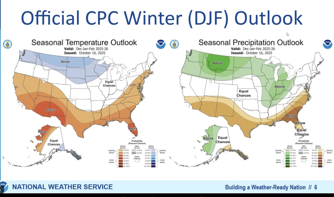
The winter outlook overall shows a 40-50% chance of below normal temperatures and above normal precipitation, with a somewhat lower chance but still above normal precipitation in the southeast section of the state.
“This is certainly something to be paying attention to, where you’ve got all the state favored – at least leaning towards – above normal precipitation,” Jones said.
That outlook for cooler than average temperatures remains from January into April. The Climate Prediction Center is less confident about precipitation chances from February-May, with no clear outlook.
Although snowfall outlook is difficult to assess, weak La Nina years do support a more active season, Jones said.
“There are some signs that during weak La Nina winters, you end up with a more active back half to the season,” she said, suggesting snow in January-March. However, she said models also suggest it may be a more active season for snowfall overall.
Jones noted it is rare to have three consecutive seasons with snowfall well below average. Bismarck, which averages 50.5 inches of snow, recorded about half that last winter and just over 60% of normal the previous winter.
“Historically, and with the forecast and some of the things we’ve seen in guidance, we are just finally going to get more snow than we have in the past two years,” Jones said. “We also do typically get a December storm when we’re in this pattern. How strong the storm, where it is – that’s still to be determined, for sure, but we do typically see some sort of December storm when we’re in this pattern.”
Long-term predictions can be fickle, though, as Jones pointed out.
“Even though we are favored for below normal temperatures and above normal precipitation, there is always a probability that is not going to happen. This is kind of the world we live in, especially with climate forecasting, where it can be pretty hard to categorize an entire season,” said Jones, who noted the current outlook is valid for three months. “Again, we’re certainly more strongly favored for near normal to below normal temperatures, but for the Bismarck area, there’s around a 24% chance that we end up with above normal temperatures for that season.”
Local News
Assistance available to hire STEM interns
FARGO – The North Dakota Established Program to Stimulate Competitive Research (ND EPSCoR) has announced ...

Police investigate Christmas jewelry store burglary
Driver charged with negligent homicide
A Minot woman now faces a count of negligent homicide charged in connection with a pedestrian crash near the Ward ...
Fedorchak’s staff to hold mobile office hours in Minot
Congresswoman Julie Fedorchak’s staff will hold mobile office hours Tuesday, Jan. 13, from 12:30-2:30 p.m. in the ...

City, county councils discuss library, zoning concerns
Williston Basin Petroleum Conference set for May
BISMARCK – The Williston Basin Petroleum Conference will be held May 19-21 at the Bismarck Event Center, bringing ...