As first storm leaves a stronger winter storm invades North Dakota
Second storm targets eastern ND

Kim Fundingsland/MDN Minot escaped the worst of a winter storm that struck the city overnight Wednesday, but it was still a very early start to the winter season. Most trees in the city were still laden with leaves.
Winter stepped up to the plate in the Minot region overnight Wednesday, but it delivered more of a change-up than a fastball. Nevertheless, even with the Minot area escaping the worst of the first of two back-to-back storms, a sudden strike was delivered.
So certain was the National Weather Service that an ultra-nasty first winter storm of the season would cross the state that it issued a Winter Storm Watch for Minot on Tuesday when the temperature was a very warm 75 degrees. In seeming defiance of shirt-sleeve weather the watch was later changed to a Winter Storm Warning.
As the storm system progressed across Montana and its precise path became more apparent, Minot was right on the edge of the warning area. Meteorologists warned in a late Wednesday morning press conference held by the Bismarck bureau of the NWS that Minot could see well over a foot of snow, accompanied by high winds and temperatures in the upper 20’s.
By Thursday morning it was evident that the region had escaped the worst of the storm and that snow totals in the area were considerably less than what the storm was thought capable of dropping. Minot’s total was three inches according to readings at the North Central Research and Extension Center south of the city. However, the wet snowfall was preceded by rainfall that brought the 24-hour precipitation total to .63 inches.
On the heels of the wettest September in recorded history, October seems destined to break moisture records as well. Through Thursday morning, just nine days into the month, Minot had already received 1.56 inches of October precipitation, placing it 21st most of all-time and over the average for the month of 1.16 inches. The all-time record for October precipitation in Minot is 5.54 inches set in 1994.
Elsewhere in the state snow totals from the first of two storm systems also proved to be less than the forecasted potential. Harvey and Dickinson recorded four inches, Hazen 3.5 and Max, Underwood and Willow City three inches each.
As the first of the two storm systems moved out of the immediate Minot area the NWS doubled down on early warnings about a second and more powerful storm system. By Thursday afternoon a Blizzard Warning was issued for a multi-county area east of Minot.
To be gleaned from the warning was that the second storm wouldn’t be sneaking in the back door but rather crashing down the front wall. Some of the potential snowfall totals issued by the NWS for the second storm are staggering, even by North Dakota standards.
Although the exact path of the storm could swing a few miles one way or another and greatly effect snowfall totals for an area, the overall message delivered by the NWS had not changed from their Wednesday declaration that warned of a “potentially historic” storm.
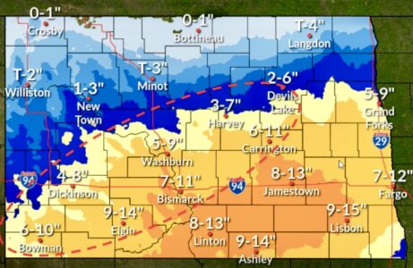
Included in an “expected snowfall” map released by the NWS Thursday morning was an unheard of 36-48 inches for Langdon, 30-36 inches for Devils Lake and Carrington and 24-30 inches of snow for Belcourt, Harvey and Jamestown. If realized, the storm will make a mockery of more than 100 years of snowfall records.
Making things worse for those in the path of the storm, says the NWS, will be winds that could approach 60 miles per hour. The Blizzard Warning stated that “40 to 60 mph winds will occur Friday into Saturday, which will result in whiteout conditions and large, impassable drifts” in Towner, Cavalier, Benson, Ramsey and Eddy Counties.
Furthermore, said the NWS, impacts from the storm could include several days of impossible travel, localized power outages, tree and structural damage from a heavy snow load and disruption to agricultural and livestock operations.
The NWS reminds travelers that the latest road conditions for North Dakota can be found at dot.nd.gov/travel or by calling 5-1-1.
The North Dakota Game and Fish Department issued a statement Thursday encouraging pheasant hunters to be wary of travel conditions. The state’s popular pheasant season opens Saturday. Game and Fish is asking hunters to be aware of road conditions and strongly discourages hunters from driving on “soft, muddy roads, trails and section lines.”
The Minot area, like much of the state, will also experience considerable wind through Saturday. Straight winds in excess of 30 miles per hour with gusts close to 50 mph are forecast. Snowfall through the period will likely be less than five inches in the city.
Although the two similar systems are being referred to as the first winter storms of the season it’s not even Halloween or Thanksgiving yet. The first official day of winter is Dec. 21.
Local News
Funds available to improve maternal health in ND
FARGO – Organizations supporting maternal health care in North Dakota are invited to apply for a Maternal Health ...

Western Plains Opera, MSU Theatre to present ‘Chicago’
Minot to escape worst of snowstorm
Parenting book study begins April 8
A free book study on “Raising Good Humans” will be held online on Tuesdays from April 8 through May 6 at 6:30 ...

Local event benefits military members at Minot AFB
Minot Symphony Orchestra to present ‘Pirates of the Caribbean’
The Minot Symphony Orchestra will present Disney’s "Pirates of the Caribbean: The Curse of the Black Pearl" in ...