When the river raged
Historic flood of 2011
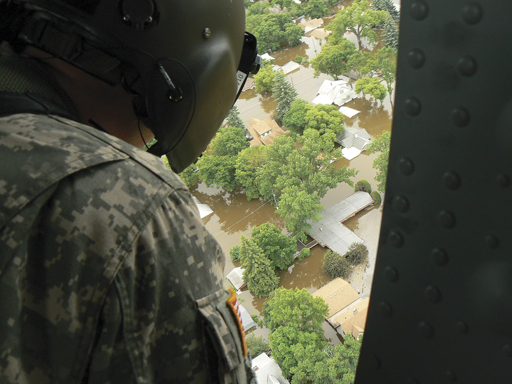
Kim Fundingsland/MDN This photo was taken from a Blackhawk helicopter as flooding began in the City of Minot in late June 2011. The water would rise several more feet in the following days.
In this year of severe drought conditions the Souris River looks lifeless and tame and harmless. But in 2011 it rampaged and tore through the City of Minot and the entire Souris River Basin in a devastating and historic fashion, flooding homes and businesses and leaving mud, debris, and misery in its wake.
The early warning signs of potential flooding were everywhere, yet few people could grasp what the end result would be. To most people it just didn’t seem possible that the aging Souris could rise to the rooftops of homes in Minot. But it did.
Minot’s unique geographical location situates it below four reservoirs – Rafferty, Grant Devine (formerly Alameda), Boundary, and Lake Darling. Rafferty and Grant Devine were constructed to add additional flood protection above Minot after the flood of 1969 that severely crippled the city. That flood was rated as a “1 in 100 years” event.
While the additional reservoirs proved valuable several times over the years as protective buffers against high spring runoff, they also meant a large amount of water was being stored above the city that would soon experience what many believed to be a “1 in 500 years” event.
Warning signs

Kim Fundingsland/MDN Many Minot residents were forced to evacuate their homes due to impend
In December 2010, the Saskatchewan Watershed Authority, now the Water Security Agency, issued a statement saying “above normal precipitation during this past summer and fall has left much of the eastern portion of Saskatchewan saturated” and that “rivers and creeks are flowing at rates well above normal.” Quite ominously, the statement included that there was flow in streams “which are normally dry in the fall.”
There were ample warning signs in North Dakota too. Water was flowing across fields and low spots throughout the region, even in January in the midst of a freezing North Dakota winter. Numerous hillsides were slumping and caving as their moisture-laden soil gave way.
By mid-January ranchers in the Towner area, where large meadows are relied upon to annually produce hay for livestock, reported the water table in some areas had risen from 8 feet to 3 1/2 feet and sump pumps that hadn’t run since 1959 were running constantly. Later in the month the National Weather Service declared that “major flooding” was probable once the spring melt got underway.
In the Saskatchewan drainage that feeds the upper reaches of the Souris River, very heavy snowfall was reported on top of ground that already contained 200% of normal moisture. By February 1, 2011, Canada warned of the “potential for above normal spring runoff throughout all of southern Saskatchewan.”
On Feb. 18, 2010, the NWS issued a very ominous Flood Potential Outlook for the Souris River Basin. The forecast warned of “well above-normal” chances of flooding along the Souris and cautioned that the amount of snow and water sitting in the basin was a “tremendous amount” and “probably in the top three” in 60 years of data.

Kim Fundingsland/MDN Contractors work furiously to raise and strengthen a dike to protect a section of North Broadway from rising floodwaters.
The International Souris River Board met in Regina, Sask. on Feb. 23 with the threat of flooding one of the major items on their agenda. A flood event was declared and the U.S. Army Corps of Engineers was alerted. The City of Minot did not have a representative at the meeting.
A few days later the Corps stated, “This year seems to be setting up to be different. The ground is wet and saturated and the airborne survey shows a lot of water content.” The NWS reported the snowpack water content to “rank among the highest” in the past 60 years.
The NWS continued to warn about the potential for dangerous flooding. An updated Flood Potential Outlook issued March 3, 2010, stated there was “significantly more water in some areas” than was earlier estimated.
Later, on March 28, NWS Hydrologist Allen Schlag made a power-point presentation to the Elmer Jesme Conference of Counties held at the North Central Research and Extension Center immediately south of Minot. Although the presentation was a highlight on the conference’s agenda, no one from the City of Minot or Ward County attended. In his presentation, Schlag detailed the massive amount of snow and water in the Souris River Basin and called it, “a recipe for disaster.”
Response begins

Kim Fundingsland/MDN The Perkett School area, a low section of the city, was particularly vulnerable to rising flood floodwaters that quickly overwhelmed sandbags and other attempts to protect property in the area.
On March 30, the Corps, which had taken over operation of Lake Darling Dam, announced they would be cutting back on releases from Lake Darling into the Souris River because they were “close to our drawdown target.” On the same day the City of Minot began preliminary plans for emergency diking for protection against a possible 7,000 cubic feet per second of water in the Souris. Existing dikes in the city were believed to protect against flows of 5,000-5,500 cfs.
On April 12, releases through Lake Darling Dam were cut from 2,400 cfs to 1,500 cfs at the direction of Corps headquarters in St. Paul, Minn. On the same date a record flow of 6,790 cfs was recorded in Long Creek, a tributary of the Souris that enters Boundary Reservoir near Estevan. Additionally, another Souris tributary, the Des Lacs River, was “outperforming our expectations” according to the NWS.
Todd Sando of the State Water Commission offered his view of the saturated situation on April 14. “There will be a tremendous amount of water moving for a long time,” concluded Sando. A day later the United States Geological Survey claimed “Highest Souris Streamflow in 40 years.”
Lake Darling, the last point of defense against high water flows in the Souris above Minot, had reached a level of nearly 1,600 feet where overflow is 1,601.8 feet. The Corps, following an assessment of the existing levee systems through Minot and Burlington, determined 19 items to be “unacceptable” for flood protection.
April 19 saw the Souris River rise to 19.17 feet at the Sherwood crossing where flood stage is 18 feet. The Saskatchewan Watershed Authority said that “Rafferty Reservoir is filling, not releasing” and that the top end of the Canadian drainage on the Souris still has “about 100% snow cover.” A day later the USGS declares “New Record Streamflows for Souris Basin.”

Kim Fundingsland/MDN As water surged into Minot in 2011 many homes succumbed to the mercy of the Souris River.
Within a few days it was readily apparent that warnings about even more water, more dramatic rises on the Souris River, were destined to come true. Releases from Rafferty Reservoir were ramped up to 2,118 cfs with the hopes of keeping flows at Sherwood at 3,200 cfs or below in accordance with treaty obligations between the U.S. and Canada. Sherwood was already flowing at 3,800 cfs. By the 26th the flow in the Souris at the Boy Scout Bridge on Minot’s west side reached 5,440 cfs and flooding began. It was only the mild beginning of what would become horrendous flooding.
The Saskatchewan Watershed Authority announced that “The Souris River broke all-time flow records in its upper reaches, snow remains and flows are increasing.” Allen Schlag, NWS hydrologist, explained that Canadian runoff is at “levels they’ve never seen before and I think it is reasonable for changes to occur.”
With flooding just getting underway in the Minot area and certainly not yet to critical levels, a three-member Federal Emergency Management Association team toured Ward County to see areas impacted by high water, primarily roads that were impassable due to flooding. A Blizzard Warning issued by NWS prompted the Corps to cut releases from Lake Darling from 4,000 cfs to 3,600 cfs, increasing the rise rate of the shallow reservoir.
By May 2 Rafferty Reservoir was eight feet over its previous record high at 1,816 feet and a mere two feet below overflow. Localized flooding was reported in nearby Estevan, Sask. Boundary Reservoir, which is connected to Rafferty by an overflow channel, was 2 1/2 inches from spilling. On the same day the Corps cut flows from Lake Darling Dam to 3,000 cfs.
Two days later the Saskatchewan Watershed Authority increased releases from Rafferty and Grant Devine Reservoirs combined to 3,530 cfs.

Kim Fundingsland/MDN When the flood waters of 2011 receded contents of flooded homes were piled on boulevards throughout the city as the sad and lengthy rebuilding process got underway. July 13, 2011, photo.
“We expected the news. It was just of matter of when,” remarked Alan Reynolds, Ward County Emergency Manager.
On May 5 The Minot Daily News reported nearly all goals regarding the spring melt have been met or exceeded with the expectation that all will go higher. Tony Merriman, NWS, cautioned that “there is still a lot of unknowns in regard to the amount of water that may come down the Souris from Canada.”
May 10 saw The Minot Daily News travel to Rafferty Reservoir to witness the release of water through that facility and reported that the “Souris River upstream from Minot is nearing uncontrolled status.”
A fury was well underway. Releases from Saskatchewan dams reached more than 4,900 cfs on May 10 and both Rafferty and Boundary Reservoirs were declared “pass through” facilities, meaning that inflow was so high that they could no long be used as regulatory structures. Flows of up to 10,000 cfs were predicted at Sherwood. With a weather forecast threatening rain, the Corps again decreased releases from Lake Darling Dam from 3,800 cfs to 3,500 cfs.
One day later the Saskatchewan Watershed Authority announced that both Rafferty and Boundary were at maximum capacity and could no longer store additional runoff. Grant Devine was expected to reach overflow within a few days. A monstrous surge of water yet to come down the Souris River was imminent.
The NWS warned all locations along the Souris River to “prepare for one of the lengthiest water events in history” as a new Flood Outlook increased water level projections throughout the Souris River Basin. Releases from Lake Darling were upped to 5,000 cfs. Flow at the Boy Scout Bridge reached 5,940 cfs and flood stage of 1,549 feet was reached at Minot’s Broadway Bridge.
The following day, with minimal flood prevention measures underway at some locations in Minot, Saskatchewan releases were upped to 9,390 cfs with more than two feet of additional water expected at Broadway Bridge by nightfall. Canadian flows were believed to still be 5-7 days away.
“Rafferty is full. Boundary is full. Long Creek (which enters Boundary) is running high and Alameda (Grant Devine) will be full. Lake Darling is expected to fill. When you add them all up, the cumulative is that it’s pretty ugly,” said Allen Schlag, NWS.
“There’s no stopping the water. There’s just no way around it,” added Reynolds.
Releases from Lake Darling were cut from 4,000 to 3,700 cfs in an attempt to buy some time for additional flood preparations within the city. It wouldn’t last long. The following day Lake Darling was opened up further, this time to 4,400 cfs.
May 15 saw a flow at Sherwood of 8,500 cfs and increasing, likely to 9,420 cfs according to the NWS. With high inflows entering Lake Darling and that impoundment filling rapidly, the release gates at Lake Darling were opened to their greatest capacity ever, 4,800 cfs. By May 19, that number was 5,000 cfs. The Souris River at Baker Bridge below the Upper Souris National Wildlife Refuge reached 16.04 feet, second highest ever recorded at that location.
The Minot Daily News, attempting to learn more information for the general public, was evicted from an Emergency Operations meeting at the First District Health Unit. The following day the City of Minot held its first press conference since the start of the runoff season and impending flooding, announcing opposition to increased releases from Lake Darling.
An email from the Ward County Homeland Security Planner, after Alan Reynolds had been removed from his position, read, “We do not invite the media because we want to ensure that we get the accurate information to you to avoid any confusion.”
For the first time city crews responded to the impending situation by erecting Hesco barriers along Fourth Avenue Northwest in a macabre operation to protect against a possible flow of 7,000 cfs.
Roland Hamborg, Corps of Engineers, said “The reservoirs on the Souris are full or nearly full. It’s a dilemma trying to manage this.”
Evacuations ordered, rescinded, ordered
On May 21 many basements in the city were reported to be taking on water due to a rising water table. Two days later water began to enter low areas of the city and the NWS called for “additional rises.” “We’ve got problems,” said Curt Zimbelman, mayor.
Just a day later, on a Tuesday, meeting in special session, the City Council requested the services of the Corps of Engineers.
“They tell me they’ll start opening the gates to Lake Darling on Thursday. It’s a race,” said Alan Walter, Minot public works director.
Normal flow time for water released from Lake Darling to reach Minot was believed to be about 48 hours. By Thursday, May 26, city crews were called up for hasty dike construction and upgrades as needed in Minot. Citizens of the city were told there was no immediate need to evacuate but should “consider” preparations to do so. The following day Lake Darling was inches from spilling and releasing 5,800 cfs, more water than Minot’s existing dike system was designed to hold. Upstream the situation worsened.
“It’s an extraordinary event that is getting beyond the flood they were designed for,” remarked Hamborg as rainfall was forecast.
On Tuesday, May 31 Col. Michael Price, Corps of Engineers, announced “There will be flooding in the City of Minot” as “all available contractors” began working on secondary dikes to protect vital infrastructure. The following day an estimated 10,000 Minot residents began mandatory evacuation of their homes following a noon announcement urging people “to get out of harm’s way as soon as possible.”
The flow in the rampaging Souris was now expected to be 10,000 cfs, far more than the city’s initial hope to be able to contain 7,000 cfs, yet the city allowed anxious evacuees to return to their homes one week later with much more water still to come.
It was on June 2 that 8,000 cfs was being released from Saskatchewan reservoirs and the Corps said to expect 6,000 cfs at Sherwood. On June 6, with the Sherwood gauge climbing and flows on the increase, a secondary dike that had been erected along 16th Street in the area of Minot’s Water Treatment Plant, was being removed. The next day the fourth highest flow in history was recorded at the Sherwood gauge. Two days later Lake Darling releases were upped to 7,500 cfs, then 8,100 cfs.
“If Darling fills, if there is no storage, Minot is as susceptible to flooding as a town with no dam,” said Joshua Scheck, NWS. “You are living one day at a time because each rain storm is a bullet that needs to be dodged.”
On June 15, citing the Corps as a source, Mayor Zimbelman tells the city at a noon press conference that 3,730 cfs is coming down from Canada. A website in Estevan placed the number the previous day at 5,118 cfs. By the 19th the releases from Canada surged to 19,415 cfs, far more water than the system could contain and far too much headed to the City of Minot. Mandatory evacuations were ordered once again.
“Rating curves just don’t apply anymore,” said Schlag.
As dawn arrived on Tuesday, June 21 came the astonishing news that nearly 30,000 cfs was surging down the Souris River Valley from Canada, so much water that it made its own course, making a mockery of the river channel and historic flow times. It was coming quick, very quick.
“What I see right now is probably the most devastating in terms of the number of people directly impacted and what it will do to damage homes as water begins to overtop the levees and fill in behind,” said Major Gen. David Sprycznynatyk, N.D. National Guard.
Minot’s evacuation deadline was moved from 10 p.m. to 6 p.m. the following day. The deadline to vacate the river valley in Minot came early due to water that was rising faster than anticipated. It was signaled by the eerie sound of sirens wailing throughout the city. Minot Mayor Curt Zimbelman told flood weary residents that, “We’re looking at another seven feet of water.”
It was a Friday, June 24, when the Souris River peaked at the Sherwood crossing above Lake Darling at 29,700 cfs, more than double the previous record. Lake Darling, on the brink of overflow with a tremendous amount of water entering the reservoir, was necessarily releasing a dangerous deluge of 26,000 cfs.
“It’s a stupendous amount of water for the Souris,” said Schlag. “The cat is way out of the bag and there’s a lot of pain heading towards Minot.”
Floodwater reached the gutters and shingles of hundreds of homes in the city, many recently constructed on the city’s east side. The crest of the devastating flood of 2011 was reached Saturday, June 25 at 1,561.8 feet at Minot’s Broadway Bridge, nearly 13 feet above flood stage.
It would be several weeks before floodwaters would recede enough to allow residents to assess the damage and begin the lengthy and laborious clean-up and rebuilding phase. Many, physically and mentally exhausted, simply moved away from the carnage to begin a new life elsewhere.
-

- Kim Fundingsland/MDN This photo was taken from a Blackhawk helicopter as flooding began in the City of Minot in late June 2011. The water would rise several more feet in the following days.
-

- Kim Fundingsland/MDN Many Minot residents were forced to evacuate their homes due to impend
-

- Kim Fundingsland/MDN Contractors work furiously to raise and strengthen a dike to protect a section of North Broadway from rising floodwaters.
-

- Kim Fundingsland/MDN The Perkett School area, a low section of the city, was particularly vulnerable to rising flood floodwaters that quickly overwhelmed sandbags and other attempts to protect property in the area.
-

- Kim Fundingsland/MDN As water surged into Minot in 2011 many homes succumbed to the mercy of the Souris River.
-

- Kim Fundingsland/MDN When the flood waters of 2011 receded contents of flooded homes were piled on boulevards throughout the city as the sad and lengthy rebuilding process got underway. July 13, 2011, photo.