Souris River Canoe Trail
Wonderful river opportunity

Kim Fundingsland/MDN Dam No. 1 is an end point for the Souris River Canoe Trail. Unfortunately, low water so far this year has not provided favorable conditions for canoeists. Anyone considering canoeing the river at J. Clark Salyer NWR should contact refuge headquarters for the latest river conditions.
UPHAM – It is one of the most scenic and interesting trips in the state – the Souris River Canoe Trail located within the J. Clark Salyer National Wildlife Refuge.
Canoeists can choose from 5 1/2, 7 1/3 and 13-mile trips. This year though, due to very dry conditions, paddlers are reminded to check on river conditions the refuge headquarters before planning a trek.
When flows in the Souris allow, however, the route is enchanting. From water level, flanked on each side by the wooded bottomland of the Souris River, the canoeist can easily imagine a step back in time. Around each bend of the meandering river a new adventure awaits, be it a moose stepping down the bank to get a drink or a great blue heron looking down from a perch high above.
There’s waterfowl too, a great variety of waterfowl from colorful wood ducks to the ever-present Canada geese. It takes only a few minutes on the water for a person to understand why the Souris River Canoe Route earned its designation as a National Recreation Trail.
At the midway point of the trail lies the Thompson well, a sloping access point where it is very easy to bring a canoe to the bank. A few steps away is refreshing Thompson well, a hand-pumped well that was once a centerpiece of an old farmstead at the same location. A picnic table and comfort station makes Thompson well an ideal stop for anyone using the river or traversing the nearby Scenic Trail auto tour route.
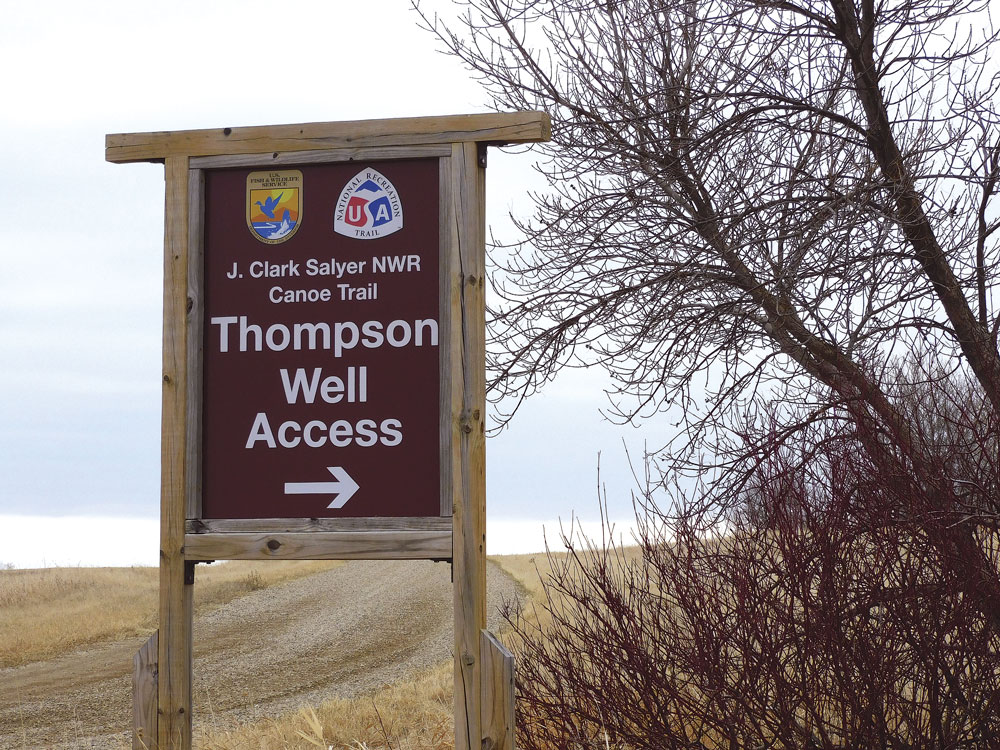
Kim Fundingsland/MDN Easy access to the Souris River can be found at the Thompson well site on the J. Clark Salyer National Wildlife Refuge. The water route is designated as a National Recreation Trail.
“There’s still a lot of people using that well for drinking water, making coffee and such,” said Gary Williams, J. Clark Salyer NWR.
Unfortunately so far this year, river conditions have fallen victim to an on-going drought with little or no flow in the Souris and falling water levels.
“The water is so low, and there’s a lot of log jams,” said Kyle Flannery, J. Clark Salyer NWR project leader.
With rainfall though, conditions could change, even if for a short period of time. If a rising river makes the trail useable, it is well worth the time to get a very unique perspective on what North Dakota has to offer.
-

- Kim Fundingsland/MDN Dam No. 1 is an end point for the Souris River Canoe Trail. Unfortunately, low water so far this year has not provided favorable conditions for canoeists. Anyone considering canoeing the river at J. Clark Salyer NWR should contact refuge headquarters for the latest river conditions.
-

- Kim Fundingsland/MDN Easy access to the Souris River can be found at the Thompson well site on the J. Clark Salyer National Wildlife Refuge. The water route is designated as a National Recreation Trail.
-

- Kim Fundingsland/MDN From the access point at Johnson Bridge the Souris River Canoe Trail can be paddled as a 5 1/2, 7 1/2, or 13-mile trip. When conditions are right, the entire trail takes about 7 hours to complete. River conditions this spring are very low due to extremely dry conditions. Prospective canoeists are advised to check river conditions at the J. Clark Salyer NWR headquarters prior to planning a trip.

Kim Fundingsland/MDN From the access point at Johnson Bridge the Souris River Canoe Trail can be paddled as a 5 1/2, 7 1/2, or 13-mile trip. When conditions are right, the entire trail takes about 7 hours to complete. River conditions this spring are very low due to extremely dry conditions. Prospective canoeists are advised to check river conditions at the J. Clark Salyer NWR headquarters prior to planning a trip.