
ND winter outlook leans warmer, drier
Trending
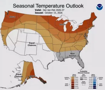
The warmer weather pattern this fall is expected to slowly transition into winter, which also could be warmer than normal in North Dakota, according to the winter outlook released by the National Weather Service Thursday, Oct. 15.
Above normal temperatures are expected to continue through January, with indications February and March could be closer to normal, said meteorologist Megan Jones with the NWS Bismarck office.
The National Oceanic and Atmospheric Administration is forecasting a super El Nino pattern will bring warmer temperatures to the plains.
Jones noted "warmer" is relative when talking about North Dakota winters. However, NWS hydrologist Allen Schlag said records from past strong El Nino years commonly show temperatures averaging several degrees above normal during certain months.
"The net effect of these types of winters - where we have these warm outbreaks that bring the average temperature up so much - is that by the time we get into the March timeframe, and certainty into April, we have very little snowpack remaining on the ground for our normal spring melt season, and that snowpack is absolutely imperative for healthy rivers, healthy streams. Of course, without it, it's very difficult to generate any kind of flooding," Schlag said.
Flood forecasts begin to be released each year in February.
"If you really like winter and you are hoping for a lot of snow - I think about the ice on the lakes - it's probably not going to be a great year for that," Jones said. "Winter recreation, unfortunately, will probably have a tough year."
"What you aren't going to hear a lot about are good ski reports coming out of Montana," Schlag added. The impacts of that lack of snow also could be felt in the Missouri River system and Lake Sakakawea in the spring.
Schlag said El Nino years tend to be drier overall, but again, like average temperatures, some months can be outliers due to short-lived weather drivers. For instance, during 1966, an El Nino year, March saw 22.7 inches of snow in Bismarck, up from the average of 8.5 inches and the sixth snowiest March in 139 years of data. February of 1998, another strong El Nino year, was the second wettest February on record in terms of rain and water in the snow.
"It looks like the first measurable snow - probably not until late October to November, especially across the southern part of the state," Jones said of this season's forecast. The prediction model doesn't send a clear signal on whether precipitation will be more or less than usual, she said.
"There's no tilt one way or the other," Jones said. "Right now, "I've been kind of telling people below normal snowfall, generally 50 percent of normal for Bismarck."
Schlag estimated snowfall of roughly 28 inches in Bismarck as opposed to the average of 50.5 inches, based on records of past strong El Nino winters, of which the most recent was 2015-16.
"Of course there are chances for mixed precip events," Jones said. "It could even be rain if temperatures are warm enough."