Minot to escape worst of snowstorm
Screenshot
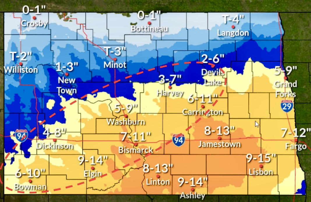
Minot and the rest of North Dakota’s northern tier is forecast to escape the worst of an April snowstorm expected to bring more than a foot of snow to parts of the state by Saturday afternoon.
The National Weather Service released a weather update Thursday, April 2, indicating Minot could get from a trace to 5 inches of snow, depending on how the storm tracks and the forecast modeling inputs.
The NWS issued a winter storm warning for all of southern North Dakota and most of eastern North Dakota. A winter weather advisory exists for most of the northern counties, including McKenzie, Mountrail, Ward, McHenry, Pierce and Rolette. Williams, Divide, Burke, Renville and Bottineau lie outside the advisory area, although there is a chance of a trace to 2 inches of snow, with the larger amounts in Williams County.
Anyone traveling south or east could encounter nasty conditions, however.
“There is a high chance of at least six inches of heavy, wet snow across much of southern North Dakota, with low to medium chances of exceeding 12 inches of snow,” meteorologist Megan Jones said. “There are some breezy winds that could cause patchy blowing snow, mainly while snow is falling. But the good news is that we’re not expecting widespread blowing snow concerns, which is something that we can typically see with these spring storms.”
The NWS in Bismarck is reporting 9-15 inches expected in southcentral and southeastern portions of the state through Saturday afternoon. Somewhat less snow of up to 4-10 inches is expected in the southwest. Fargo is predicted to see 4-12 inches and Bismarck 5-11 inches.
The northern edge of the heaviest snow is uncertain. However, Thursday’s modeling showed estimated new snow around Minot and northcentral North Dakota as minor before 6 a.m. Friday, April 3. Minor snow was expected to continue into Friday morning, with moderate snowfall in the afternoon. Minor snowfall also is expected into the evening before coming to an end, with little to no snow on Saturday.
The snow falling in the north will be somewhat drier and fluffier than in the southeast, although the NWS doesn’t forecast a flooding risk in any part of the state, given the projected slow melt.
Between cold and wet, livestock producers dealing with calving are being advised to remain alert to the conditions. The weather service was predicting a high in the mid-30s for Friday and mid-40s for Saturday in the Minot area.
Blake Rafferty, meteorologist in Grand Forks, noted the snowfall would move out of eastern North Dakota on Thursday, April 2, but the bigger concern is the second round coming on Friday and lasting until Saturday afternoon. The forecast predicted 2-9 inches for Grand Forks in the second round.
The model from the Grand Forks office also showed 1-5 inches of snow for Minot, which differed from the trace to 3 inches predicted by the Bismarck office. Jones said different ranges can be the result of timing of the background probabilities or use of differing time ranges. Depending on how the storm tracks, there could be wide variations of snow accumulations around the Minot area, the NWS stated.
Local News
Funds available to improve maternal health in ND
FARGO – Organizations supporting maternal health care in North Dakota are invited to apply for a Maternal Health ...

Western Plains Opera, MSU Theatre to present ‘Chicago’

Minot to escape worst of snowstorm
Parenting book study begins April 8
A free book study on “Raising Good Humans” will be held online on Tuesdays from April 8 through May 6 at 6:30 ...

Local event benefits military members at Minot AFB
Minot Symphony Orchestra to present ‘Pirates of the Caribbean’
The Minot Symphony Orchestra will present Disney’s "Pirates of the Caribbean: The Curse of the Black Pearl" in ...