Spring to bring unpredictable weather to ND

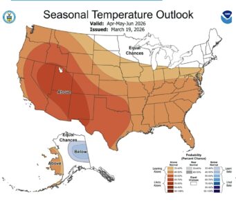
Submitted Graphic A map from the National Oceanic and Atmospheric Administration shows equal chances of temperatures being warmer or cooler than normal across most of North Dakota from April through June. A portion of southwestern North Dakota has a 33-40% chance of being warmer than normal.
Sidebar headline: Drier winter could mean earlier field work
Ward County saw below average moisture this winter, and if it stays dry this spring, farmers could get a jump on their field work, according to Paige Brummund, North Dakota State University Extension agent for Agriculture and Natural Resources in Ward County.
However, it really is too early in the season to say with any confidence that rainfall will allow spring’s work to be earlier than average, she added.
Weather forecasters don’t have a clear picture for spring precipitation, either, although they note accumulated snow this winter has melted in most areas of the state. Brummund also said the many brief warm-ups and thaws have resulted in reduced snow cover for this time of the year.
Main story:
April could bring the same temperature swings that have yoyoed area residents over the past couple of months, according to the National Weather Service’s latest outlook.
NWS meteorologist Megan Jones and NWS hydrologist Allen Schlag released information on current soil conditions and the weather outlook for spring and summer across North Dakota on Thursday, March 19. In general, no major spring storms are foreseen as the state transitions into what could be a somewhat warmer than usual summer, they concluded.
Jones attributed the deviance that occurred from the NWS’s previous forecast – predicting colder weather than actually materialized from December through February – to a weak La Nino weather pattern. La Nina is the cold phase and El Nino is the warm phase of climate patterns based on sea surface temperatures in the Pacific Ocean.
“Even though we did have those La Nina conditions they were pretty weak, and it ended up not having the influence that we thought it would have on the temperature. So, we did not see those cooler temperatures that we were expecting,” she said.
Precipitation over the winter also was as up and down as the temperatures. The Minot region saw extremes of both above or below normal precipitation, depending on the specific area.
The state remains in a weak La Nina, but there are signs of a wetter pattern coming in April, Jones said.
“We are really expecting more of the same over the next four to eight weeks – up and down temperatures, occasional shots of moisture,” Jones said. The NWS’ newly released April outlook gives equal chances for below or above normal temperatures and below or above normal precipitation for nearly all the state, which Jones said reinforces the prediction for continuation of the existing inconsistency.
Monthly summer temperatures and precipitation will depend on when the transition from La Nino into an expected El Nino occurs, Jones said. However, she said, there are signals that summer precipitation will be variable as always, with August being a little wetter than the other summer months.
Schlag said measurements of the top four inches of soil show normal to plentiful moisture over much of the state. Soil moisture was remarkable early in March due to snow melt, but that has been coming to an end, leaving the majority of the state with closer to normal soil moisture, he said.
North central North Dakota is average to slightly above average for soil moisture, he said.
Soils outside of the southwest portion of North Dakota are wet and frozen, creating nearly impermeable surfaces should rain come along, Schlag said.
A key factor going into spring, particularly in the Fortuna, Mohall, Minot and Bottineau areas, is the depth of the frost, Schlag said. Frost depths of 49 inches exist in the Minot and Mohall areas. Unable to penetrate the frost, rain would run off and could create overland flooding.
“I would say this area is somewhat susceptible to any type of heavy spring rain event,” he said. “The farther west you go – say by Williston – we’re losing frost depth at a pretty rapid rate, and then when you get to the north central and more eastern measuring points, we still have plenty of frozen ground to contend with going through the next several weeks.”
At this point, though, there is no hint of a problematic spring rain, he said.
Although an El Nino pattern, expected for this summer, commonly encourages drought, Schlag voiced little concern given current soil moisture.
There may be some concerns in western North Dakota, where constructed dams and dugouts for livestock might not fill this spring, given the current forecast, he said.
“This is where I see the biggest threat coming,” he said. “Without consistent rainfall once we get through our snowpack, I do envision with the warmer temperatures in the summertime – especially, we’re talking about the potential for warmer than normal temperatures – we can very easily start seeing rapid expansion of the drought. I don’t want to call that a forecast, but it is certainly something that is very possible once we get through the end of March.”
Currently, the only drought designation in North Dakota is a small area between Fargo and Grand Forks.
The main area of the state with significant snowpack yet is the Turtle Mountains. Some areas there still have as much as 4 inches of snow water equivalent, which could raise flooding concerns along Willow Creek.
“We’re going to continue to monitor that pretty closely over the next several days as they’re clearly going to be having warm enough temperatures up there to where we do expect to start seeing increased runoff,” Schlag said.
Spring fire risk isn’t expected to be a major concern, though, particularly in areas such as around Williston where soil conditions suggest an early green up, Schlag said. Jones added fire experts indicate the spring is shaping up to be a normal fire season.
Local News
Registration open for summer youth recreation programs
Registration is open for the Minot Park District’s summer youth recreation programs. The programs offer a ...

Minot AFB youth earns 2026 honor
Library merger committee considers public vote
A committee looking into a potential merger of the Minot and Ward County public libraries would like to see a ...
Applications sought for recreational trails grants
BISMARCK – The North Dakota Parks and Recreation Department has announced it is seeking trail project ...

AFGSC surgeon general visits Minot AFB