
Potential parks highlight Minot placemaking
Public gets look at project concepts
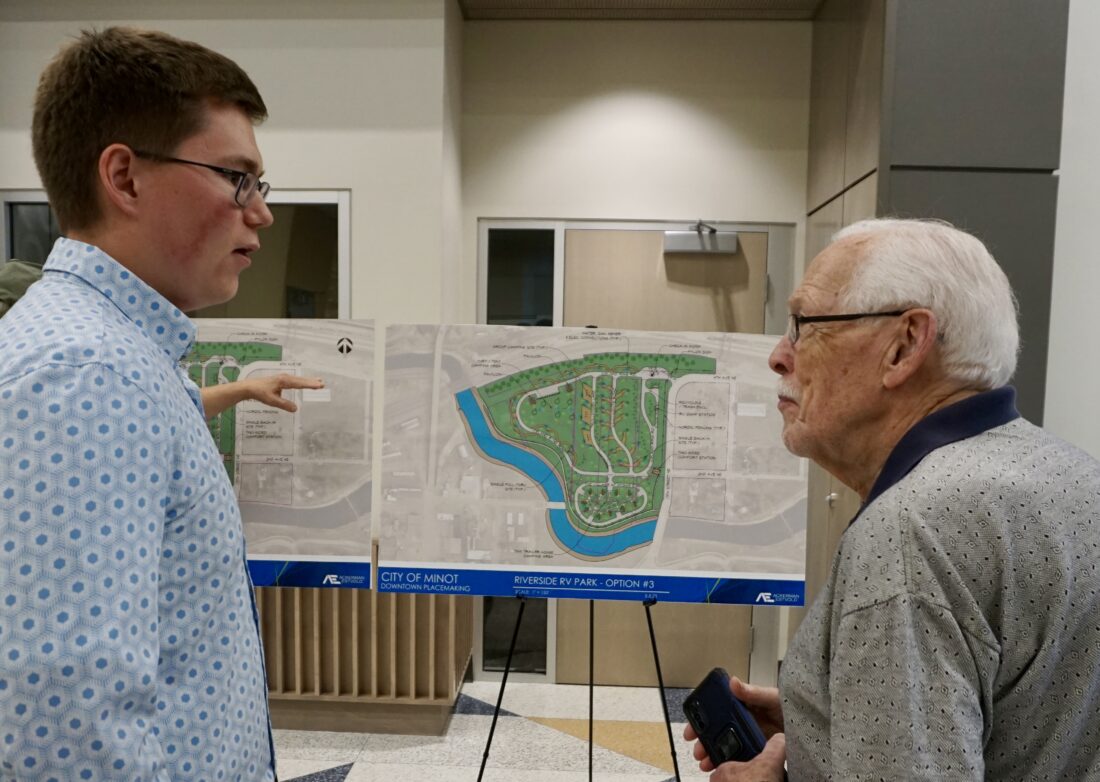
Jill Schramm /MDN Jett Skar of Ackerman-Estvold, left, visits with Minot resident Ron Chiles about the RV park concepts on display at a placemaking event in Minot City Hall Thursday.
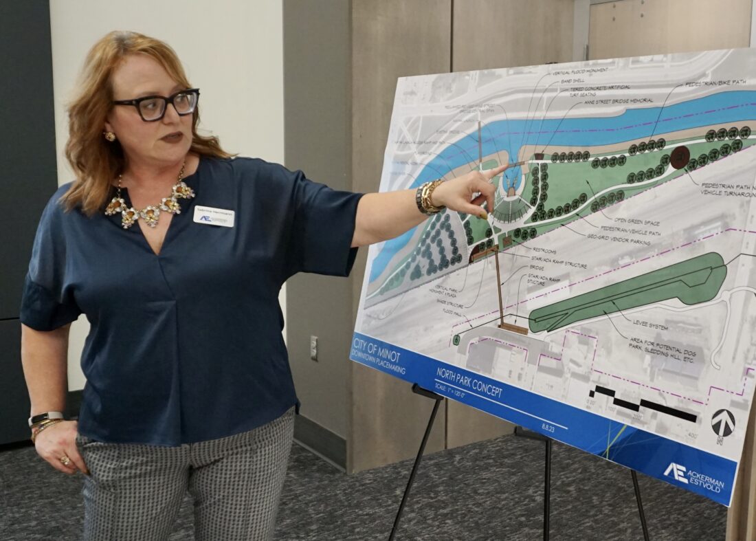
Jill Schramm /MDN Sabrina Herrmann with Ackerman-Estvold explains the concept plans for a downtown riverside park. The City of Minot and Ackerman-Estvold held an open house Thursday to give the public a look at ideas for riverside properties and in downtown.
Jill Schramm /MDN Jett Skar of Ackerman-Estvold, left, visits with Minot resident Ron Chiles about the RV park concepts on display at a placemaking event in Minot City Hall Thursday.
Jill Schramm /MDN Sabrina Herrmann with Ackerman-Estvold explains the concept plans for a downtown riverside park. The City of Minot and Ackerman-Estvold held an open house Thursday to give the public a look at ideas for riverside properties and in downtown.
Trending
Minot residents had a chance Thursday to weigh in on ideas for an RV park, downtown pocket parks and a riverside park with a kayak launch, amphitheater and new pedestrian bridge.
The City of Minot and Ackerman-Estvold presented concept drawings and laid out a vision for the downtown and the flood protection greenway at a public open house.
In total, outlined projects are estimated to cost $14.1 million to $27.4 million. In addition to determining where the money might come from, discussions still are needed regarding who would operate the potential future parks, according to Ryan Ackerman with Ackerman-Estvold, which developed the concepts for the City of Minot. The city received a state placemaking grant for the planning.
"This is not a part of any capital improvement plan," Ackerman said. "This is about step two of 100 before we even get to the point where we're actually able to build something. So we're very early on in the process."
The concepts were developed over the summer with a group of stakeholders that included Minot Park District, Visit Minot, Downtown Business & Professional Association, Minot State University, North Dakota State Fair, Minot Public Schools, Minot Area Chamber EDC, Renaissance Zone Board and Souris River Joint Board.
Ackerman presented high-density and low-density concepts for a recreational vehicle park in the former Ben's Tavern area, west of Seventh Street Northeast and south of Fourth Avenue. Both concepts include a typical RV-style campground and a separate primitive camping area. They would have check-in kiosks and comfort stations with restrooms and showers.
The lower density option comes with a Scandinavian theme, apparent in signage, fencing, landscaping and in mobile camping units, much like tiny houses on wheels. Whatever entity manages the campground would own and rent out the units, Ackerman said.
An RV park could cost roughly $1 million to $6 million to construct, depending on the features, he said.
A proposal for a riverside park north of downtown has been addressed previously in a River Front and Center project in 2013 and more recently by North Dakota State University architectural students. Ackerman said stakeholders discussed an active recreation park with pickleball courts and pump tracks or a passive recreation focus with a botanical garden and orchards.
However, the plan chosen for presentation takes a recreation and entertainment focus, including an amphitheater overlooking a manmade bay holding a flood memorial and providing access to a kayak and canoe launch. The truss of the Anne Street Bridge would span the neck of the bay. The remainder of the bridge would be discarded, but historical documentation would be preserved in a display.
The base of the flood memorial would be at the water's surface, with three legs extending upward to mark flood elevations in 2011, 1976 and 1969.
"The 2011 water surface would be about 24 feet above the normal water surface so that would be a fairly substantial monument in that regard," Ackerman said.
The plan also envisions a playground, walking trail, continuing the presence of the existing Victoria pedestrian bridge, a path for vendors to bring in food trucks, public restrooms and a vertical land monument.
Vehicle access would be from the west, through the Maple Diversion channel. It means vehicle access would be closed if water needs to flow through the diversion. Ackerman said temporary loss of access could statistically happen once every 10 years.
Completion of the Maple Diversion will allow for eliminating Souris River dead loops in Oak and Nubbin parks.
"We will have a continuous waterway from 16th Street Southwest near the dam by the water treatment plant all the way down to Roosevelt Park. The coffer dams at Oak Park and Nubbin Park will still remain but the river connections are going to be reestablished so that a canoer or a kayaker won't have to portage or go over the top of the dams," Ackerman said. "You can kayak down the river through all of Oak Park, through all of Nubbin Park, and potentially exit out of this new water access point at this north downtown park, and that is a full four miles of river length."
The park also would have separate bicycle access not affected by the Maple Diversion, along with a new 250-foot pedestrian bridge over the railroad tracks for access from downtown.
The rough estimate for the park is $8 million to $15 million, which could be impacted by any required environmental work at the former industrial site. Of that cost, the pedestrian bridge accounts for $5 million to $6 million.
Downtown pocket parks are envisioned that would include artwork, plantings, benches and information kiosks. Water features and fire pits also are possible design elements. Residents were shown concept drawings for pocket pockets at the intersection of Main and Second Avenue, near City Hall, and Main and Central Avenue. The rough cost estimate is $50,000 to $200,000 per park, depending on features.
If funding wasn't a drawback to getting started, the pocket parks could be constructed as soon as next year, Ackerman said. The campground would have to wait for flood protection construction to finish in that area, pushing the operational start to 2026. The north park would have to wait until after construction of the Maple Diversion in about 2028, so that project would be on the more distant horizon even if it had funding, he said.
The City of Minot plans to eventually make the placemaking documents available on its website. The city is taking public comments but needs to wrap up planning under the state grant by Sept. 1.