
Burgum declares statewide emergency for spring flooding
Trending
BISMARCK - Gov. Doug Burgum issued an executive order Monday, declaring a statewide emergency for spring flooding. However, most of the Minot region is reportedly secure at this time.
Soaring temperatures and heavy snowpack are expected to produce widespread flooding across the state this week and next week, especially in eastern North Dakota, according to the governor's office. The executive order officially puts all state agencies, including the North Dakota National Guard, on standby to provide resources and capabilities as needed. The state has been mobilizing public and private partners to prepare for and assist in the flood fight since the start of the year.
Ward County is facing no flood threats at the current time, according to Ward County Emergency Management Director Kelly Haugen.
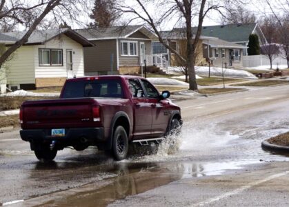
The Ward County Highway Department had a minor incident with water over a road but it required no intervention before resolving on its own, County Engineer Dana Larsen said. He said crews have been checking roads for any culvert backups that might lead to flooding.
"Just because it's warming up so quickly some of the culverts may not be completely open when the water gets there," Larsen said. County crews will be using using steamers on ice build-up or pushing snow away from culverts as necessary. There may be instances in which snow in ditches could cause water to flood roads as well, so Larsen advices motorists to be watchful in coming days.
"We are not anticipating any disastrous flooding," he said. "The biggest thing is for people to be aware of water running over the road and not to drive through running water," he said.
In McHenry County, Emergency Management Director Kelsey Siegler said several areas of concern are being monitored, particularly related to the Souris River and Wintering Creek. Some spring flooding is typical, but becomes of the rapid snowmelt, Siegler said the expectation is there will be more overland flooding and roads impacted.
Minot faces no flood-related issues with the Souris River, Public Works Director Dan Jonasson reported. Crews are steaming open any frozen catch basins where water may pool, as they do every spring, he said.
Other area counties say they have no major flooding concerns at this time.
The executive order activates the State Emergency Operations Plan to assist local and tribal officials, alleviate hardships, implement appropriate recovery actions and future mitigation measures, and facilitate restoration of services and infrastructure.
"Deep snowpack that's ripe for melting will combine with a rapid warmup this week to put North Dakota's flood fighting skills to the test once again, so it's essential that state agencies be ready to respond at a moment's notice," Burgum said in a release. "North Dakotans are experienced flood fighters, and working together with our local, state and federal agencies in a whole-of-government approach, we can overcome whatever challenges lie ahead."
In addition, legislative leaders planned to propose $2 million for natural disaster response and recovery funding as an amendment to the Office of the Adjutant General's budget.
"As citizens prepare for the worst and hope for the best in communities and rural areas across North Dakota, the Legislature stands fully ready to support the state's flood response and recovery efforts," House Majority Leader Mike Lefor and Senate Majority Leader David Hogue said in a joint statement.
At least six counties - Cass, Dickey, Grand Forks, LaMoure, Pembina and Richland - have issued emergency declarations to address flooding and storm impacts, and additional counties are considering declarations.
The state reports that flood outlooks issued by the National Weather Service point to the potential for significant river, tributary and overland flooding in the Missouri, James, Sheyenne and Red river basins, with Top 10 flood crests possible in many locations.
The governor's office urges residents to prepare for flooding before it happens, including determining whether they're in a floodplain and identifying the fastest way to higher ground and which nearby roads are most likely to flood. For more information, visit www.weather.gov/flood.
For those curious about their flood risk, NDRAM is a flood-risk identification portal that conveys flood warnings and U.S. Geological Survey flood-stage data in the "Weather" tab. Those looking to purchase flood insurance or who have questions about existing flood insurance policies are encouraged to contact their flood insurance agent immediately.