A study of the Souris River hopes to determine cause of loss of flow between Lake Darling and Verendrye
Study underway on Souris River
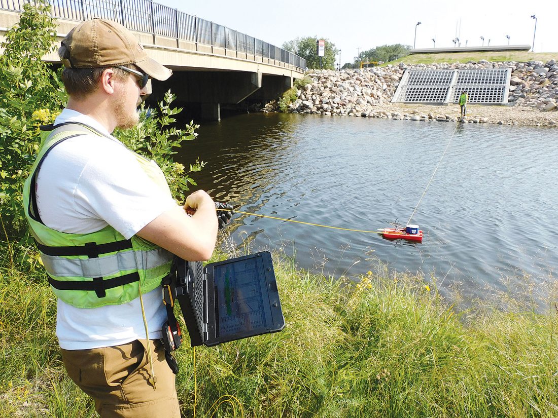
Kim Fundingsland/MDN Spencer Wheeling, U.S. Geological Survey hydrologist, Bismarck, was helping conduct a study of the Souris River this week. The study hopes to determine the reason for flow loss between Lake Darling and Verendrye.
What is happening to the water in the Souris River? Sure, it’s a very dry year, but why water is disappearing on its way downstream is puzzling.
“Some of the earlier releases this summer from Lake Darling didn’t even make it to Minot,” said Tom Pabian, Upper Souris National Wildlife Refuge manager. “This study is to see why that was the case.”
The U.S. Fish and Wildlife Service, U. S. Army Corps of Engineers, North Dakota Department of Water Resources, and U.S. Geological Survey hope to find the answer. Teams of USGS personnel ascended on the Souris River from Baker’s Bridge to Verendrye this week, including measurements taken at the Boy Scout Bridge west of Minot, just above the Broadway Bridge, and near Muus Lumber on the city’s east edge.
“During this extreme dry period water being loosed from Lake Darling upstream doesn’t always make it downstream. We’re trying to target where the water might be going into some type of groundwater storage,” said Brent Hanson, USGS, Bismarck. “It’s basically an opportunity to better understand how the river and groundwater interact at lower flows.”
Following the extreme high water of the 2011 flood, well after the water had receded, river flows were increased by excess groundwater making its way back into the river. The opposite may be occurring during the current low water period, with the river refilling underground storage.
“During normal years with higher flows you don’t really recognize that. Once water gets low enough it’s a higher percentage that we are losing,” said Spencer Wheeling, USGS hydrologist who was actively sampling Souris River flows Tuesday. “If you have a flow of 40 cubic feet per second and are losing 10 cfs it is more noticeable than if you are losing 10 cfs out of 400.”
While 10 cfs of water is not a lot, it is during a low water year, especially when considering the Souris is an International Waterway with Canada and the United States sharing water rights. The Souris has its origin in Saskatchewan, Canada, flows south into North Dakota, and returns north to the province of Manitoba.
“There are certain rules and regulations so Canada gets a certain amount of water back across the border. So, it’s very important to keep track of where it’s all at,” explained Wheeling. “If Lake Darling is releasing water to get back into Canada but it’s losing it into the ground, that’s something to look at how to control and work with international neighbors.”
Wheeling was using an Acoustic Doppler Current Profiler, or ADCP, to help assess Souris River flows. To assist with the study, Lake Darling began releasing 50 cfs on Aug. 10. Those releases ended Wednesday as USGS personnel were completing their data gathering.
The ADCP is a miniature boat tethered on opposite banks of the Souris and drawn slowly back and forth. A transducer, similar to a fish flasher used by ice fishermen, sends out acoustic sound that goes down and bounces back. It measures a variety of water activity, including suspended particle movement and movement on the riverbed.
“The purpose of this whole thing is to determine how much water is flowing by the gauge at Broadway Bridge,” said Wheeling while conducting a test of Souris River flow just above Broadway Bridge on Tuesday. “We’ll get a cubic feet per second at this point in time.”
By comparing data from several points along the river, the USGS hopes to pinpoint where water is escaping from the meandering Souris. It’s not an easy process to determine with precision where that might be, and will require extensive analysis of data to arrive at a conclusion.
“We’re not quite sure on a timeline, when we’ll be able to finalize that,” said Brent Hanson, USGS, Bismarck. “We’ll be publishing a report, maybe with a week or two.”
The release of water from Lake Darling, 50 cfs, began Aug. 10 and has had minimal effect on the level of water at that facility. Lake Darling stood at approximately 1,592.75 feet Wednesday. The lake’s normal summer operating level is 1,597 feet and winter level 1,595 feet. Canadian reservoirs on the Souris are also well below normal operating levels during what has become one of the driest periods in history for much of the U.S. and Canada.
Local News
‘Kites and Currents’ set at Confluence
Bismarck man dies in rollover near Towner
TOWNER — A 63-year-old Bismarck man died from injuries received in a one-vehicle rollover on Willow Road and 67th ...
MSU foundation tax exemption gets scrutiny
Spring wildfire potential remains high
BISMARCK — Despite recent snowfalls across the state, outdoor enthusiasts should remain aware of ground ...

New LWV chapters reflect interest in voter outreach