
Drought conditions returning to North Dakota
More dry weather ahead
Trending
Soil conditions are dry over much of the state and getting drier. That's the take away from the latest compilation issued by the United States Drought Monitor.
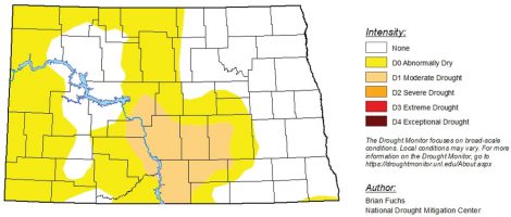
According to the Monitor, just over 54% of the state is considered to be "abnormally dry" with more than 11% falling into the "moderate" drought category. The Drought Monitor uses five designations to define drought conditions. They are abnormally dry, moderate, severe, extreme and exceptional drought.
The dry conditions of concern cover about two-thirds of North Dakota from the western border with Montana to the eastern third of the state. The eastern half of Ward County is in the abnormally dry area while the soil moisture in the western half of the county is considered normal.
Much needed rainfall that came in late June and early July alleviated what was an expanding area of severe drought conditions, particularly in the central area of the state. All of Ward County was considered in moderate drought earlier this summer as well.
While the rainfall was timely and supplied much needed moisture to crops and haylands, overall rainfall totals throughout much of the state remain well below normal. As of Thursday Bismarck's rainfall total was 6.33 inches below normal, Dickinson 5.41 inches below normal, Hettinger 7.61 inches below normal, and Minot 2.80 inches less than normal.
Harvest is either underway or about to start over much of the region. Although some rain would be welcome over much of the state's cropland, too much rain could result in a delayed harvest due to soggy soil.
Rainfall recorded at the North Central Research and Experiment Station south of Minot totaled 2.94 inches in June. The long-term norm is 3.58 inches. July rainfall, which included 1.45 inches that began falling on the last day of June, reached 2.84 inches or about one-half inch more than normal.
Thus far August has been a much different story with a scant 0.23 inches of rain recorded over the first two weeks of the month. The August average is low however, at 2.04 inches. Perhaps more telling is the yearly rainfall total of 9.56 inches through Thursday as compared to the long-term norm of 13.44 inches for the same date.
There doesn't appear to be much of an opportunity, other than a few thunderstorms, for meaningful or widespread rainfall in the days ahead that could reverse the trend of expanding dry conditions. The Climate Prediction Center';s latest 8-14 day precipitation outlook rates most of North Dakota to be in the "probability of below" average rainfall for the period ending Aug. 26.