More snow, colder says latest outook
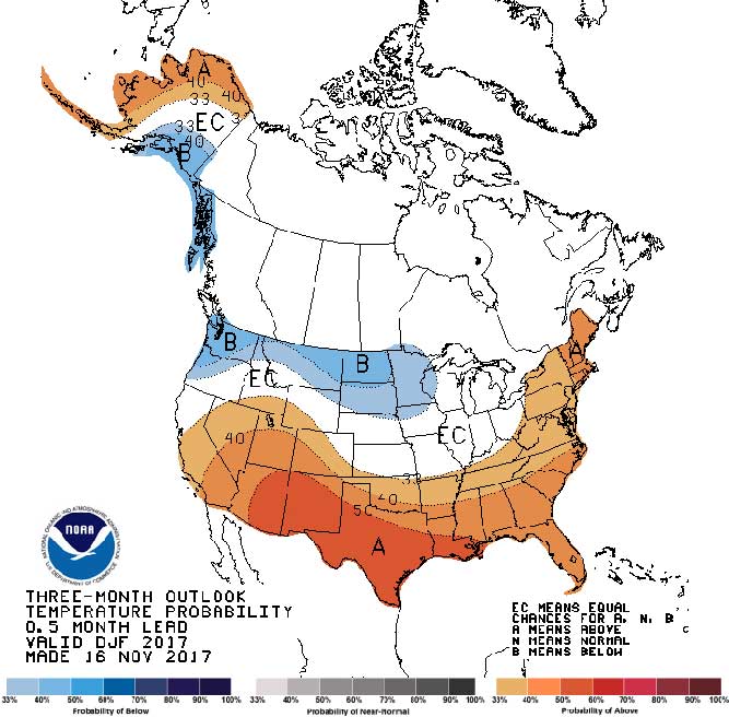
The latest long-range weather outlook issued by the Climate Prediction Center isn’t good news for those wishing for a mild winter for North Dakota. The outlook calls for an enhanced chance of colder than normal temperatures and the possibility of greater than average snowfall for the period December-February.
The main culprit is a lurking La Nina, a cooling of Pacific Ocean temperatures. The CPC recently upgraded a La Nina Watch to a La Nina Advisory. At this time La Nina conditions are considered weak and not likely to develop into a system that will have a great influence on North Dakota’s winter, but still strong enough to put a damper on any hopes for a prolonged stretch of unusually nice weather in the months ahead.
The CPC refers to their latest long-range outlooks as “heavily influenced by ongoing La Nina conditions that are forecast to continue through late winter.” In past years a strong La Nina would often lead to an abundance of miserable winter days on the Northern Plains. The good news is, this La Nina is not so strong based on statistical comparisons from 1981-2010.
Nevertheless, the December-February temperature outlooks favors “enhanced odds for below-normal temperatures” and “increased chances of above-normal precipitation” for much of the northern United States, Minot and North Dakota included. This La Nina presence is expected to be somewhat spotty with a mixture of normal and below-normal temperatures and snowfall expected. And there’s no mention of a somewhat mild and dry winter.
For the short term, though, there are some very warm winter temperatures in the forecast. Highs on Sunday and Monday are expected to sneak into the 40s.
Local News
Funds available to improve maternal health in ND
FARGO – Organizations supporting maternal health care in North Dakota are invited to apply for a Maternal Health ...

Western Plains Opera, MSU Theatre to present ‘Chicago’
Parenting book study begins April 8
A free book study on “Raising Good Humans” will be held online on Tuesdays from April 8 through May 6 at 6:30 ...

Local event benefits military members at Minot AFB
Minot Symphony Orchestra to present ‘Pirates of the Caribbean’
The Minot Symphony Orchestra will present Disney’s "Pirates of the Caribbean: The Curse of the Black Pearl" in ...
Maple sugaring event on tap at Fort Stevenson
GARRISON – Fort Stevenson State Park will host Maple Sugaring Days for some sweet days of learning and fun as ...