Warm spell warnings
Ice jams, rising water possible
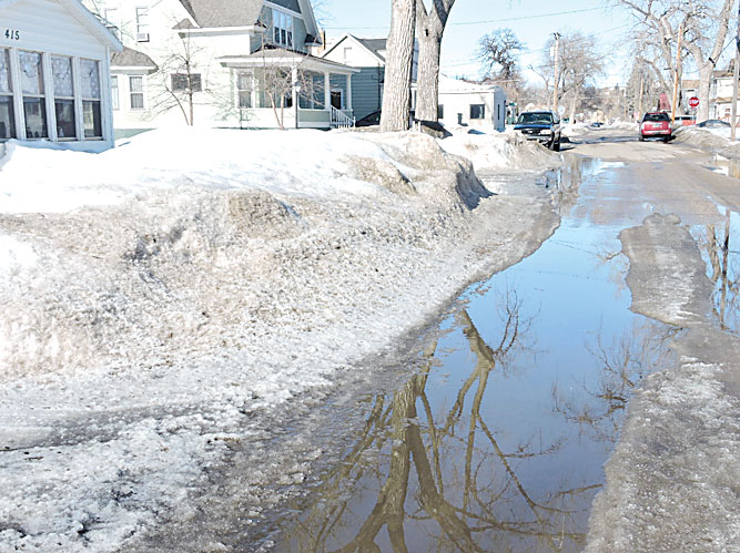
Kim Fundingsland/MDN Although there is still a long ways to go, Minot’s snowpack is slowly diminishing thanks to a spell of warm weather. Warm temperatures are forecast for the remainder of the week.
The National Weather Service warns that warmer temperatures this week have the potential to create some problems with snowmelt runoff, particularly in southern North Dakota and much of Montana. Despite temperatures in the coming days that will flirt with all-time record highs, the Souris River and Des Lacs River drainages are not expected to see any major changes.
“That’s not really on the radar yet. By and large, you still have all your snow and water sitting on the ground,” said Allen Schlag, Bismarck NWS hydrologist.
Nevertheless, some settling of the area snowpack is inevitable with rising temperatures. The NWS says Minot could top 50 degrees for a daytime high today. The record high for this date is 51 degrees set in 1913. The warm temperatures will further concentrate a snowpack that contains up to four inches or more of water in certain locales. Runoff that occurs now, however limited, will lesson the amount of future runoff expected from the current snowpack.
The NWS in Bismarck issued a statement regarding increased temperatures over the next few days, primarily for areas south of the Souris River drainage. “As warm temperatures persist, pathways will open for meltwater to reach stream and rivers, and levels will rise,” says the NWS. “Overall, this early melt should be beneficial with helping remove excess moisture from river basins in the southern and western parts of North Dakota.”
Montana is being warned that unseasonable warm temperatures “may lead to ice jam concerns as increased water movement begins to push ice that is lodged in coulees, culverts and smaller creeks.”
Earlier hydrologic outlooks for the Souris River drainage have noted near record amounts of snow over extreme southeast Saskatchewan, below reservoirs located near Estevan and Oxbow, Sask. Warm weather this week should help alleviate some concerns about future runoff by decreasing the snowpack. Daytime temperatures are expected to be in the mid-40s for the Estevan region today and tomorrow before dropping below the freezing mark on Monday.
The NWS will issue an updated Flood Potential Outlook for the Souris River today.
Local News
Building Permits
City of Minot March – Breland Enterprises Inc., 715 12th St. NE, stabilize walls, install five power braces, ...
Eagle Awards announced
The Minot Area Chamber EDC announces its Eagle Award winners for March. These individuals were nominated by ...

Gardeners can get inspired at spring event
Blood donors needed in April
This April, nonprofit Vitalant urges all who are eligible to spring into action and give blood to keep up with the ...

Preparing for White Shield casino
Deadline nears for 4-H, FFA scholarships
North Dakota high school seniors involved in 4-H or FFA have until April 15 to apply for Chevron-supported ...